
Since the inception of the Pennypack Wilderness Park, now known as Pennypack Preserve, the Trust has relied on small-scale, high-resolution surveys of flora and fauna to plan its land acquisitions and direct and evaluate its stewardship efforts. Completing these surveys required many hours of field work by skilled observers, so surveys could often only be completed every five to ten years. Increasing pressure from windstorms, flooding, and invasive species has made this rate of resurvey inadequate for directing effective stewardship interventions. Fortunately, recent widespread availability of GPS-enabled smartphones and affordable Geospatial Information Systems (GIS) software is making environmental monitoring a more continuous, accurate, and intuitive process for Trust staff.
Thanks to the support of our members, the Trust has incorporated a new mobile mapping platform that makes it easy for a small crews of interns, volunteers and staff to perform annual sweeps of every acre of the Trust. With cloud-based apps that sync observations almost instantly across devices, these annual sweeps are immediately available for use in prioritizing our stewardship work. This platform can also incorporate past and future input from visiting researchers and naturalists, allowing our interns and full-time research staff to return to these areas and assess the effectiveness of our conservation efforts. Lastly, a separate suite of mapping tools allows volunteers and stewardship staff to report issues—such as trees felled along the creek during a major storm—as they occur.
Having the scale and severity of different issues across the Preserve neatly mapped out helps our team address the most pressing concerns—like stabilizing newly exposed bank soil—while maintaining momentum on long term restoration goals—like establishing wildflower patches in our meadows. As field staff check off assignments sent to their phones, they automatically create a record of their work that can be overlaid with future observations of the same area to track progress and highlight when follow-up work is needed. Check below for stories about the people and projects involved in our exciting new land management approach!
Related Posts
Expert Botanist Returns to Kickstart 21st-Century Survey
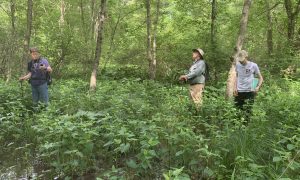
On June 6, 2019, John D. Mitchell–whose undergraduate research transformed the mission of the Pennypack Watershed Association–brought his colleague from the New York Botanical Garden (NYBG), Dr. Robert Naczi, for a whirlwind tour of some of Pennypack Preserve’s most unique and high-quality habitats. This brief exploration helped guide valuable discussion […]
Read More...